Article
Roman Frontiers
| The Roman
Frontiers, are where the Romans developed walls or control points around
the edge of its empire. In part it was defensive, but they also allowed
the control of people in to and out from the empire as well as allowing
taxes to be gathered. Today some
form part of the
World
Heritage Sites,
 Roman frontiers heritage sites. This includes a large stretch in
Germany,
Hadrian's Wall
and the
Antonine Wall
in
Britain.
Roman frontiers heritage sites. This includes a large stretch in
Germany,
Hadrian's Wall
and the
Antonine Wall
in
Britain.
Other sections of the Roman frontiers,
including more wall sections, exist in other places including Northern
Africa.
Here we are concentrating on the Roman
frontiers in Britain, and this is made up primarily of
Hadrian's Wall
in
the north of England and in Scotland, the
Antonine Wall
.
We could also include Richborough Roman
Fort near Dover in Kent, as it was the entry point into and exit point
from Britain in Roman times to the continent. It featured a large
impressive highly decorated arch which was the gateway into Britannia.
The map on the right shows one
interpretation of Roman Britain in about 150AD, of the position of major
settlements, frontiers and major roads at
|
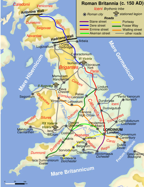 |
this point, however
some perhaps are shown before they were established, so forget the date and
look at it as more of an overall plan. The first of the Northern frontiers the
Romans built in Britain was the Gask Ridge, this was a line of forts,
that was completed 42 years before
Hadrian's Wall
was started and far to the north of it.
|
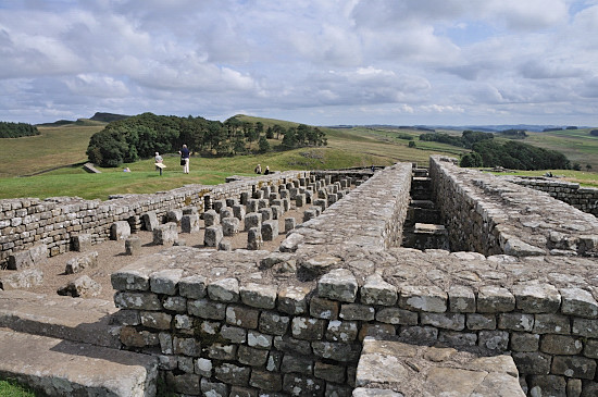
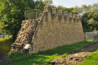
Hadrian's wall is really accessible to everyone
Many of the Hadrian's wall remains are by the
side of the road, because
a later military road went across, on a lot of
places on top of parts of the wall.
So you can undertake hill walking or visit by
car.
This section at
Denton Hall Turret
 and
others like
Sycamore Gap
that featured in a Robin
Hood film, below can be photographed from the
road. and
others like
Sycamore Gap
that featured in a Robin
Hood film, below can be photographed from the
road.
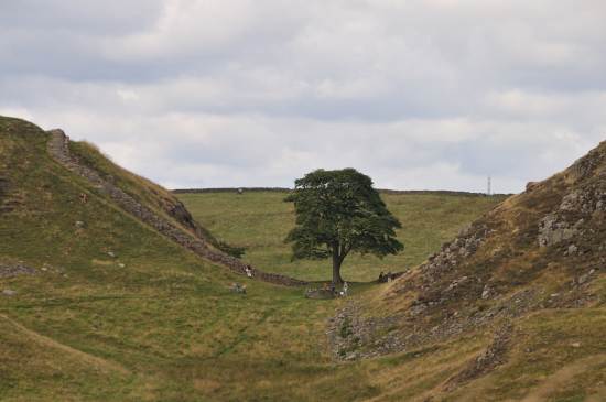
see
Hadrian's Wall Route Guide
 for a car route with short for a car route with short
walks to see all the main remains |
It was also further North than
the
Antonine Wall
constructed later. There are suggestions that the Gask was the first Roman
frontier to be constructed anywhere.
Many of you reading this will not have
come across Gask before, its little known and not fully researched. Many of
the sites are known as visible from the air, but studies into signalling
from one to another of these, suggests there are other sites still to be
discovered. In a similar way we know the decisive battle of Mons Graupius,
that the Romans won, and was north of the River Tay, somewhere in
eastern Scotland, but the site has still to be found.
The 53 acre Roman
Legionary fort
at Inchtuthil,  just east of Caputh (Grid
ref NO124396
), one of 10 built in Britain, is north of
the Tay, and a part of the Gask, but unlike others it has never since been
built over, and represents the only complete Roman Legion Fort in existence
anywhere, where the full layout is available. It was excavated in the 1950's
and around 10 tonnes of nails and other metal items were found, over 750,000
items. Excavated again in 1962 and 1965, it was a large fort housing a legion
of 5,400 plus supporting personal. The site had a 5,000sq metre hospital, 64
barrack buildings. The walls, if all put in a line, would have stretched
for 7 miles. So you would expect there to be a major museum here, but no,
its just a field with a few low humps in, best viewed early or late in the
day when they are more prominent with the oblique lighting.
just east of Caputh (Grid
ref NO124396
), one of 10 built in Britain, is north of
the Tay, and a part of the Gask, but unlike others it has never since been
built over, and represents the only complete Roman Legion Fort in existence
anywhere, where the full layout is available. It was excavated in the 1950's
and around 10 tonnes of nails and other metal items were found, over 750,000
items. Excavated again in 1962 and 1965, it was a large fort housing a legion
of 5,400 plus supporting personal. The site had a 5,000sq metre hospital, 64
barrack buildings. The walls, if all put in a line, would have stretched
for 7 miles. So you would expect there to be a major museum here, but no,
its just a field with a few low humps in, best viewed early or late in the
day when they are more prominent with the oblique lighting.
| The Romans were never beaten in the
northern parts of the UK, although when legions were away they could be
overrun, it was however more of a challenge in terms of warfare and
difficult geography. So while the total
conquering of the UK would to us seem more sensible and then not
require walls to be manned, we think that there were a number of factors
that distracted from this. Its thought that the Gask was a staging
line to move further north, and complete the job, but that the Romans lost
the willpower to do so and when some forces were required elsewhere in the
Empire, so it was a judgement call with limited resources. They may
also have decided this area did not fit into their Empire model.
The Romans ran their empire by overlaying the
existing local administrative structures, they would leave the existing
rulers in power, in their existing stronghold and set up a small community
or fort nearby. Although the largest roman military force of any province
existed in Britannia, it was there to maintain control, not to run things. To
many existing rulers, although they had to pay taxes to Rome, this was an
attractive proposition, the Romans guaranteed other tribes or groups and did not
raid them, and kept the same group in power.
In the North of England they
appear to have had to provide a lot more policing as well, after the area
was fully conquered they had very many forts and watch towers that were
constantly manned.
While in England communities with rulers existed
pre Roman, in Scotland the population was far thinner and no ruling
structure is thought to have existed, so the Romans had no one to put in
power, or to run things for them. Added to this Scotland had at that time no
metal or other wealth of interest to the Romans, or traders, and the farming
communities were thin and highly scattered. Being at the extremes of their
supply chain they would have to put more supplies into maintaining a
presence than they would be able to get out in any form of taxes. So after a
relatively short period of 6 years after the only battle of note in
Scotland, they withdrew. |
  
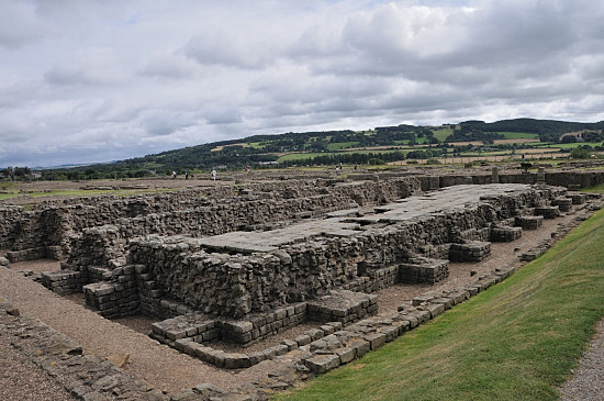
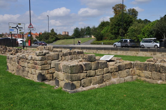
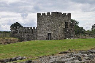
Granaries at
Housesteads
Fort
Housesteads Roman Fort
 |
|

Granaries with most o
their floors intact at
Corbridge
Roman Town
Corbridge Roman Town
|
| Many similar features can be
compared in different sets of remains, with forts, towns and more
to explore, you can also find remains and reproductions seeing
what is left and what it may have looked like when complete. |
|
Some suggest that fighting terrorism would have caused
this withdrawal, but terrorism did not exist as such in these times, with the
longest range weapon being a bow and arrow, and no explosives, all warfare
was close. The Romans don't have any records of supply problems or other
items that would suggest that any organised resistance existed. Even with
the battle of Mons Graupius, the Romans reported Britons still arriving,
and the suggestion is of a grouping of tribes without any leadership and
having been beaten these disbanded, disappearing never to be seen again.
With the exaggeration that exists in records from this time, this may not
have been a force set up to fight at all, but a grouping for some other
reason that the Romans came across. The Roman report of 30,000 Britain's is
highly inflated as there was no populations at the time in these areas that
could have mustered such a strength. One of the reasons that no one
has ever found this battle site may be that there is nothing really to find,
a few people were discovered, attacked in roman formation, scattered and
nothing occurred to leave any trace of the action.
|
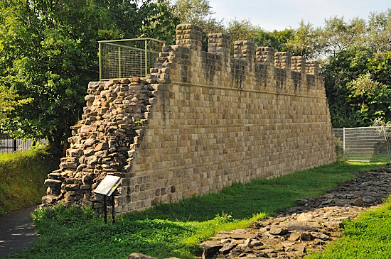
Following the establishment of
Hadrian's Wall
the Romans still had many forts and look out posts to the north of the wall,
later moving up again to set up the
Antonine Wall
for a while, before again dropping back to
Hadrian's Wall.
Both of these walls were frontiers through
which people could pass, and the number of points through which they could
pass were large. Just about all the forts and mile forts along
Hadrian's Wall
have access gates to allow people to pass through the wall. Allowing fairly
free movement and taxes to be gathered at the edge of the Empire.
However it also has, in effect, access paths or roads running along the wall
on both the north and south, so that the forts along the wall could be
reinforced from either side. There was ditch defence also both to the north
and south of the wall. So we might think of
Hadrian's Wall
as a tax border, and a line that could be defended from attack from the north or
south, and an exclusion strip to the south, just so people can't throw things
over the wall to avoid the tax.
Later the mile forts were not manned and
there were then far fewer crossing points and defences. The tooing and froing
between
Hadrian's Wall
and
Antonine Wall
occurred several times, see the article on
Hadrian's Wall
for more of the history and list of dates that activities took place on this
northern frontier. There is little to see still at
Antonine Wall
and far more along the greater length of
Hadrian's Wall, the listing
Hadrian's Wall - Featured Places
 identifies these and links to a large number of detailed location guides,
most with photographs, and some with picture galleries as well. The article
on
Corbridge
Roman Town
also provides quite a lot of background to what was happening in general. It,
like the
Roman
Vindolanda
fort predated
Hadrian's Wall
providing protection on the major roman road from coast to coast the 'Stanegate'.
identifies these and links to a large number of detailed location guides,
most with photographs, and some with picture galleries as well. The article
on
Corbridge
Roman Town
also provides quite a lot of background to what was happening in general. It,
like the
Roman
Vindolanda
fort predated
Hadrian's Wall
providing protection on the major roman road from coast to coast the 'Stanegate'.
While Hadrian's Wall goes to the coast in
the west, the Romans provided extra protection down the coast of Cumbria in
the form of more forts, milecastles and turrets, but in this case no wall.
North of the wall there were other forts,
on the west there was a group of three north of the wall that worked with
it, and its thought that along the wall there were many advance lookout
forts around 10 miles north of the wall.
Various maps have been produced that show a
large number of Roman forts and encampments all of the north of England and
a large amount of Scotland. |
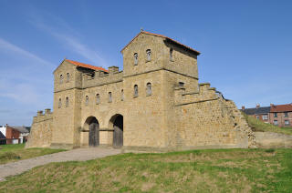
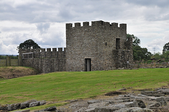
Reconstructed Fort Gatehouse
Arbeia
Arbeia Roman Fort
|
Reconstructed wall with original in front
opposite side of road at
Wallsend
Segedunum Roman Fort
|
Reconstructed turret and wall -
Vindolanda
Roman Vindolanda
|
|
|
In
addition to the walls there were many forts and fortresses as well as look
out towers located around the coast of Britain, the highest concentration of
these were near to the walls and along the southern coast controlling
movements to and from the continent. Its probable that many of these existed to make
sure goods could not pass without tax being paid.
See also:-
Gask in
Wikipedia
largely
built from information from the project site above.
Interactive
Map
of Roman forts and more in Britannia, with this you can
toggle overlays on and off to allow the exploration of the UK as a whole or a
more local area in greater detail.
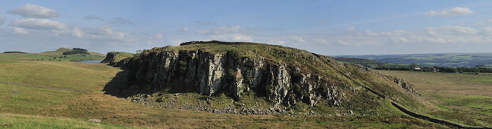
Hadrian's wall at
Steel Rigg
to get this view is a level walk across one field from a car park |